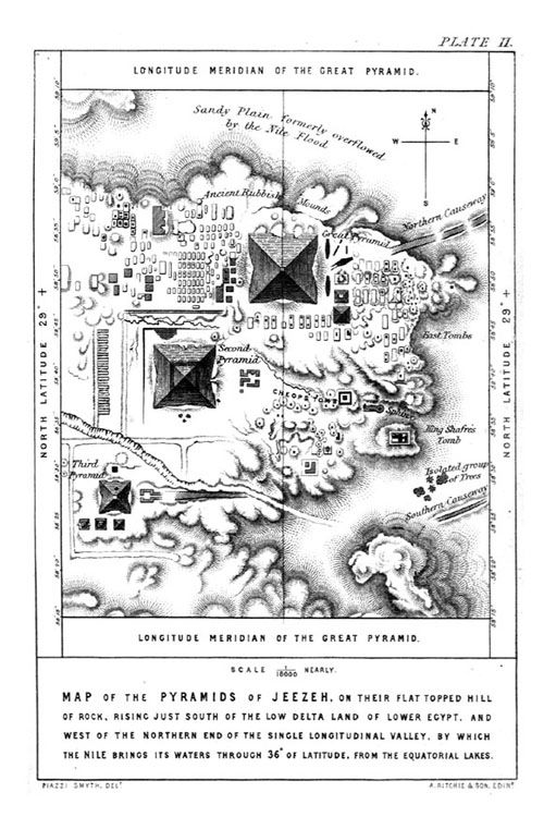
As
we see from the first set of drawings from the Smythe Exploration of the
1800�s it was well known that the Nile River flooded the sandy plain in
and around Giza.Modern
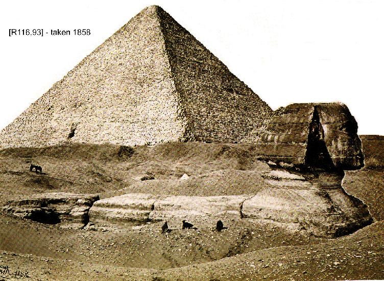
�geologist� Professor Robert Schoch has attempted to create an
�illusion� that ancient rains from the time of the mythical city of
Atlantis rained upon the Sphinx.What Schoch and his followers have failed to realize is the
simple existence of both ground water and rising waters in the area which
easily explain the lower body erosion and wear on the Sphinx.
As we will see the lower water erosion to the main body of the
Pyramid itself as incurred by the Arabs who took the fascia off the Great
Pyramid were from a different form of rising waters.See the book series, The Solomon Series: Great Pyramid Mystery
Resolved.
Notice
in the Smythe drawings of 1865 he notes an isolated group of trees down near the
southern causeway.These
trees are no longer there, but it is an indication of a high water table
under the sands at the time.As
we have seen in other photos from the 1800�s the Sphinx was partially or
mostly covered up at times during this era.Noticethe Sphinx has
minor mention in the Smythe drawing (Mid right of sketch, barely
recognizable).
As
we see in the Smythe drawing there is what he once called �Causeways�,
the �North Causeway� (upper right) and the �South Causeway� (lower
right).What Smythe�s
drawing fails to demonstrate is the size and scale of these
�causeways�.These
so-called causeways were actually walls that were 30-50 feet thick and
resembled levies in their design.
Smythe failed to understand the location, height, and influence the Nile
River had on this location.
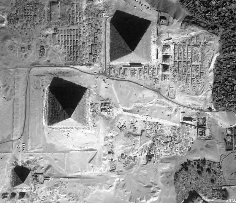
As
we look more closely at the causeways as levies we can see that the
valleys in the area were actually holding ponds like we see in the Faiyum
area today.Much of this area was at one time submerged in water, and as
the waters receded they used the sandy areas for various forms of
construction.We know based
on dating of the shafts, complexes, and graves at the bottom of the valley
that the operations in this area came many, many years after the peak of
the Giza Plateau.
It actually
appears that the pyramids themselves were a symbol of life and of power,
but following a terrific drought the area became associated with drought
and loss of power.This
scenario correlates to a period when control was shifting from the pharaoh
to a new royal nobility.This
is fully explained in Volume Five of The Solomon Series: Great Pyramid
Mystery Resolved.
Can
you see how it would look very differently to the pyramid era pharaohs
than it appears now?Are you
aware that wet lime rock would have created lush green vegetation in the
area making it look like a tropical paradise?No, this might not be a result of global warming, but rather result
of other issues in the kingdom.Get
the free eBook The Solomon Series: Great Pyramid Mystery Resolved
at www.SolomonSeries.com .
Notice
in the aerial above the trees and the above ground cemetery in the lower
right.This is also seen in
our over-view PDF drawing that is a must see for anyone:
There is much more to come. These are merely
teasers for what you will soon find in the eBook. More will be
posted to the website as we go along.
Have a wonderful day and keep
searching for truth. Ask, seek, knock!
###
Phone
1-850-685-2353
You may also go to our online
system for free electronic downloads, or for books in print purchase
products as they are available. Go to "Materials and Tools" to get the project started.
Egypt, Egyptian, Great
Pyramid, Giza Plateau, Giza Pyramids, Pyramid Drawings, Pyramid
Sketches, Pyramid Theory, Pyramid Construction, Pyramid Tombs,
Pyramidology, Pyramid Alignments, celestial alignments, Pyramid Mystery,
Great Pyramid Solved, Khufu, Cheops, Khafre, Robert Schoch, Professor
Robert Schoch, Jean-Pierre Houdin, Steven Myers, Ron Wyatt, Sir Flinders Petrie,
William Petrie, Egyptian Archaeology, Egyptian Pyramids, Egyptian
Pharaohs, Ancient Egypt, Pyramid Text, Great Architect, Freemason,
Freemasonry, archeology, Egyptology, Sphinx, Great Sphinx, Atlantis,
Atlantean, City of Atlantis